|
The Gulf of California Deflection
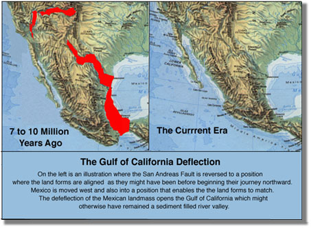
 The Gulf of California Deflection is the size of the gulf today compared to what it was when it started. The red on the map show how much the land forms were moved in order to create the alignment illustrated. When making this map it is quite apparent that you cannot simply move Baja California south and have it match up in alignment because during its migration north Mexico has moved east, bent by the pressure from the subduction of the Cocos Plate. The Gulf of California Deflection is the size of the gulf today compared to what it was when it started. The red on the map show how much the land forms were moved in order to create the alignment illustrated. When making this map it is quite apparent that you cannot simply move Baja California south and have it match up in alignment because during its migration north Mexico has moved east, bent by the pressure from the subduction of the Cocos Plate.
The time that the Baja Peninsula has been traveling north and the time that Mexico has been pushed east is consistent with the age of the Grand Canyon and the Rio Grande Rift.
|