|
|
 |
|
|
 |
 |
 |
|
The Grand Canyon
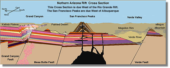
The Grand Canyon is the northern edge of a wide rift being created by the southward tugging of the Mexican Land mass. Publications of the US Park Service show the same pattern as the Rio Grande Rift. The east/west cross section of the region titled "Geologic Cross Section of the Grand Canyon - San Francisco Peaks - Verde Valley Region" three active faults tilted to the south as would be predicted by the Mexican Disconnection Theory. Between the Grand Canyon and Verde Valley the land has settled in excess of a thousand feet and the volcanoes are right in the middle of the subsiding land.
The stretching of the region is not significant compared to the Rio Grande Rift, but the Mexican Disconnection Theory predicts that it is being pulled south just as the region east of it is being pushed north to create the Colorado Rockies.
The canyon is generally believed have formed through erosion and the gradual change in elevation and slope of the western continent. This analysis shows that it is instead the result of the deep cracking of the crust as a direct consequence of the Mexican Disconnection. Erosion and changing elevation played their parts, but he initial channel was the result of the cracking of the crust and separation due to the Mexican Disconnection.
The San Francisco Peaks, the center piece of a periodically active volcano system, are about sixty miles south of the Grand Canyon and together with Verde Fault, forty miles further south, represent a Rift pattern like the one in the Rio Grande Valley.
The San Francisco Peaks will continue to be active because the rift basin continues to sink, and the volcanism of the San Francisco Peaks is the direct result of the subsidence, or settling of the rift basin. It indicates that the region's sinking has intruded onto the lithosphere and caused a significant melt of material that later rose, and continues to rise through the crust to form the volcanic cones now known as the San Francisco Peaks.
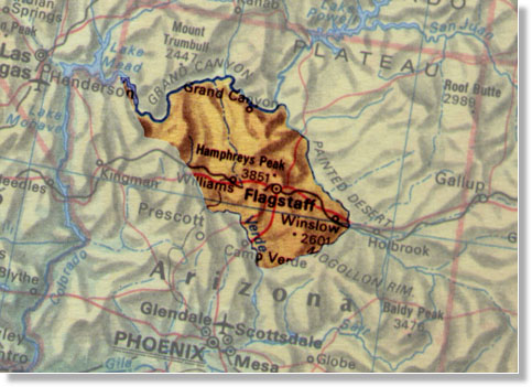
In the illustration above we can see the outline of the reagion most likely to be involved in the subsidence, or settling of the rift basin. The volcanic fields are around Flagstaff and the San Francisco Peaks. From the area north of Flagstaff south to Verde River , The entire area has dropped dramatically toward the lithosphere resulting in a substantial melt of deep crust that has made its way to the surface in the form of volcanos.
|
 |
 |
|
Copyright © 2001 Dane M. Arr All righjt reserved Mexican Disconnection˘ is trademarked by Dane M Arr |
|

